The 'Planned' Route
This page gives a full breakdown of everything we and you need to know about the schedule and route etc.
This breakdown of the route considers the varying terrain we must cover during the tour. Therefore, compromises have been made such as covering less miles on days when we are faced with intense hill climbs (like Day 1) and more miles on the days when we are covering considerably 'flatter' terrain (such as those in the Midlands).
Each of the ten days has been broken down into a daily ride with the route and places we will visit (pass through) listed in numerical order on the electronic map.
Day 1 - Land's End to Par Sands - 66.1 Miles (total 66.1 miles)
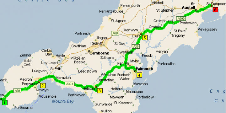
After a quick photo op at the famous Land’s End white sign post, our journey begins.
The day provides a gentle introduction to the tour through the picturesque lanes of Cornwall. The south-west peninsula is the most popular holiday destination in Britain and as such the narrow, tree lined roads that are characteristic of the area can become rather congested especially in the height of summer.
The route climbs from the granite nose of Land’s End (1) to the town of Penzance (2) before continuing along the shores of Mounts Bay to Helston (3). The Lizard Peninsula is bypassed as the route continues across country to Falmouth (4) and then to Truro (5) before once more joining the coast at St Austell and the picturesque village Par Sands (6) situated on St Austell Bay.
Because it is our first day today will be a relatively easy day covering only 66.1 miles to our first over night stop, Par Sands.
Although we are covering fewer miles on day one, we will encounter some steep gradients along the way including an initial climb of approx 600ft above sea level on the roads between Land’s End and Penzance. However, by far the biggest climb we face on day one will take place on the roads between Helston and Truro where way will tackle a gradient of approx 800ft above sea level before gradually making a soft descent down to our destination and tents!
Day 2 - Par sands to Tiverton - 82.9 Miles (Total 149 miles)
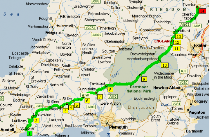
So, after a good night’s sleep and a big breakfast we leave Par Sands and head off in the direction of Tiverton in Devon. Today will be a hard ride but we must cover some ground in order to stick to our ten day target.
The route leaves the sanctuary of Par (1) and the coast and strikes out across the wilds of Dartmoor. The ascents and descents gradually become more onerous as the towns of Lotwithiel (2) and Liskeard (3) lead alongside the high ground of Bodmin Moor and into the county of Devon. We will then visit Merrymeet (4), St Ive (5), Callington (6) and Drakewalls (7) before Tavistock (8) provides a last chance for refreshments before the plateau of Dartmoor Forest is crossed.
The fringes of this beautiful wilderness are intertwined with a maze of canopied roads that interconnect to the many villages in the area. We will pass through Postbridge (9) before reaching Moretonhampstead (10) which is the largest town on the eastern fringe of the moor.
After leaving Dartmoor National Park behind us we come upon Tedburn St Mary (11), Venny Tedburn (12) and the historical town of Crediton (13) before reaching our destination and camp at Tiverton (14). As with day one, we face some tough hill climbs today. The roads between Liskeard and Tavistock promise a gradient of approx 1000ft above sea level then the roads that take us from Tavistock to Moretonhampstead steadily rise to a dizzying (approx) 1700 above sea level.
From there onwards though, you will be happy to know it is down hill all the way to Tiverton which lies approx 20ft above sea level.
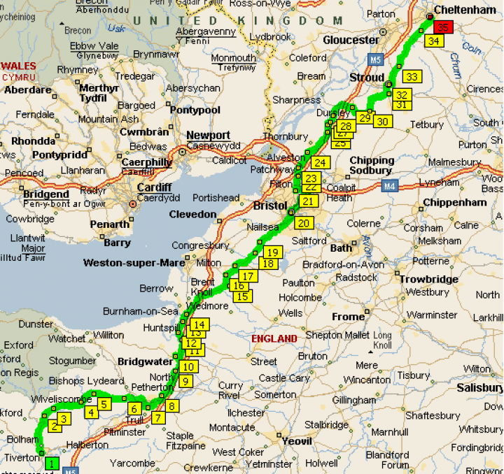
Day 3 - Tiverton to Cheltenham - 131.6 Miles (Total 280.6 Miles)
So, once again after packing up our tents, we hit the road.
Today we will cover many miles thanks to the fairly flat roads ahead of us.
After the trials of Dartmoorand the West Country the gradients we face today are minimal with the highest peaking at approx 350ft above sea level on the roads between Bridgewater and Bristol.
Setting off from Tiverton (1), following the course of the Exe Valley, the cycling promises to be delightful. The route takes us through a setting of wooded hills and meandering streams. Ahead can be seen glimpses of the Brendon Hills and Exmoor National Park. We will cross the River Bathern (by bridge!) and pass through Bampton (2) and then follow the river course in the shadow of steep sided hills to reach Shillingford (3). The road continues and we will pass Waterrow (4) and Wiveliscombe (5) before leading into the beautiful Vale of Taunton Deane. We will pass through Heathfield (6) before heading down a steep embankment into the town centre of Taunton (7).
Once we have cleared Taunton we pass through Monkton Heathfield (8) before the road turns north and begins to run parallel with the M5 into the town of North Petherton (9). To the west rise the peaks of the Quantock Hills that separate the Vale of Taunton Deane from the Somerset Plain and Sedgemoor. This vast fertile area of the Mendips is criss-crossed by a grid-like network of roads which when followed north will provide us with extensive views of the Quantock Hills before delivering us safely into Bridgwater (10). This area is quite exposed with flat, open farmland stretching as far as the eye can see and makes for easy cycling.
We will soon pass the villages of Dunball (11), Pawlett (12), Huntspill (13) and Highbridge (14) which will provide a welcome reminder that good progress is being made! At the edge of the Mendips we will pass through the town of Axebridge (15) before passing through some wonderful wooded slopes clinging to limestone outcrops and continue ever north through the villages of Winscombe (16), Churchill (17), Redhill (18) and Lulsgate Bottom (19) as the route begins the run towards Bristol (20).
Once we have negotiated the main road leading through Bristol city centre, we are quickly led out of the urban sprawl through the villages of Filton (21) and Patchway (22) before reaching the charming town of Almondsbury (23). We are now in the deepest darkest Cotswolds which promise to provide us all with sights of unforgettable beauty and some of the most imposing scenery of our journey.
Still heading north, we will contour the west flank of Stinchcombe Hill passing through the villages of Alveston (24), Falfield (25), Stone (26), Woodford (27) and Newport (28) before reaching Dursley (29).
We are now nearly at our destination. All that remains is to follow the quiet road which weaves pleasantly along the steep sided river valley before climbing through the wooded slopes past the village of Uley (30), along an undulating crest with beautiful views across the Cotswolds, through Woodchester (31), straight through the historic town of Stroud (32) and then past Painswick (33), Shirdington (34) before finaly reaching a hot shower, hot meal and a much needed camp bed at Cheltenham (35).
Day 4 - Cheltenham to Whitchurch - 109.4 Miles (Total 390 Miles)
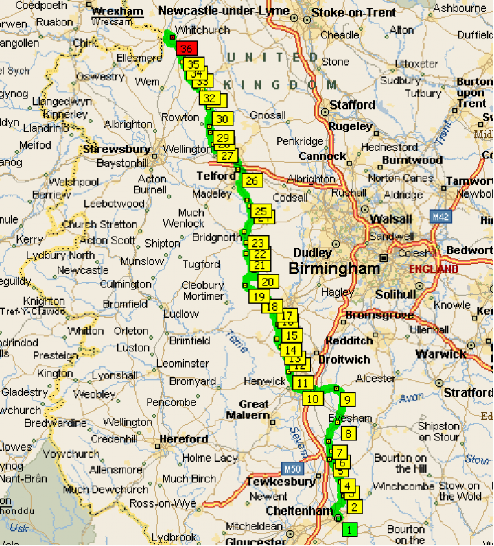
Like day 3, the route we follow on day 4 promises to be a flat one. Again, we will take advantage of the terrain and cover many miles today.
The highest hills we will face today will be approx 250ft above sea level on the roads between Buttonoak and Bridgnorth.
Following a hearty breakfast we will set off from our camp site in Cheltenham (1) and leave town heading north passing the famous Cheltenham racecourse on the right. We continue and pass the town of Bishops Cleeve (2) with beautiful views back to the steep ridge that marks the western edge of the Cotswold escarpment.
Swift progress may now be made along the flat flood plain of the River Severn. The road passes through the isolated knoll of Oxenton (3) before passing through Pamington (4), Bredon (5) and Bredons Norton (6). A little further on we come upon first the town of Eckington (7) then the beautiful Pershore (8) located on the River Avon.
We will now follow a delightfully varied course through glorious open countryside through the village of Upton Snodsbury (9) and into the medieval town of Worcester (10). From the centre of Worcester we follow the river bank further north to reach the village of Hallow (11) then onto Holt Heath (12). This area will be a delight to cycle through because of the ever changing panorama of wooded slope, narrow overhung lanes, twisting roads and ancient woodlands.
From Holt Heath we follow the course of the River Severn through Shrawley (13), Noutards Green (14), Areley Kings (15) and Ribbesford (16) before descending through the south-west peninsula of the Wyre Forest into the town of Bewdley (17). We will now be making good progress as our route continues to take us through the Wyre Forest to reach the villages of Button Oak (18), Kinlet (19), Highley (20), Chelmarsh (21) and Eardington (22) before the road turns east and follows theSevern valley Railway into the historic town of Bridgnorth (23).
From Bridgnorth we will navigate a tree lined route past the River Worfe and onto Stockton (24), Sutton Maddock (25), the beautiful telford (26) and Sleapford (27) before passing through Crudgington (28). We will then follow an avenue of rhododendrons into the villages of Waters Upton (29), Peplow (30) and Hodnet (31) before a nice descent through open countryside passing Marchamley (32), Darlinston (33), Prees Higher Heath (34) and Prees Heath (35) before finaly reaching our destination for the day, Whitchurch, Shropshire (36).
Day 5 - Whitchurch to Kirkby Lonsdale - 110.2 Miles (Total 500.2 Miles)
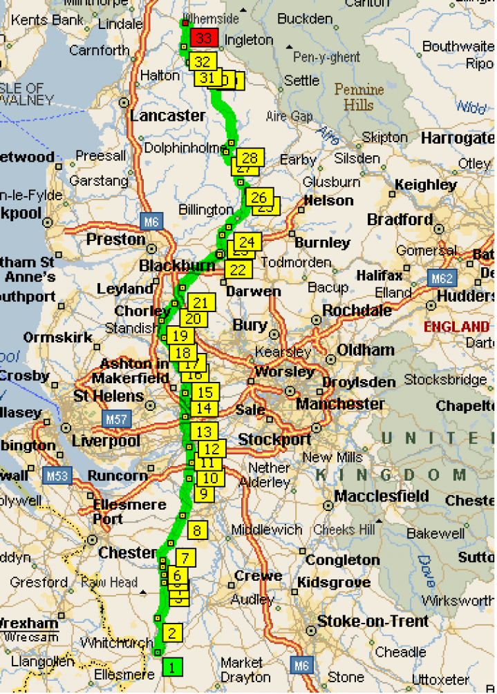
Day 5, as always, starts after breakfast. The aim of today is to take full advantage of the relatively flat terrain between Whitchurch and Clitheroe and cover lots of miles before we hit the hills again!
The roads between Clitheroe and Kirkby Lonsdale threaten to remind us of previous days spent negotiating the West Country rollercoaster roads. It will be an ‘up and down’ affair with the highest peak we must conquer lying at a scary approx 1300ft above sea level.
Leaving Whitchurch (1) town centre we will follow the road which after taking us into the county of Chester, passes a waterfowl sanctuary before crossing theShropshire Union Canal. From here, the road continues through scenic meadowland to pass the impressive entrance to Cholmondeley Castle on the left. We pass through the pretty villages of Bickley Moss (2), Spurstow (3), Bunbury Heath (4) and Tiverton (5) before a short climb leads to the village of Tarporley (6).
Ignoring the newly constructed bypass that circumnavigates the village, we follow the rural road which boasts spectacular views across the Gowy Valley. After descending into Cotebrook (7) the road continues to lead us ever onward passing Cuddington (8), Whitley (9), Stretton (10) and Stockton Heath (11) before delivering us into the familiar realm of deepest darkest Warrington(12).
An industrialised barrier stretches across the country from Liverpool in the west to Humberside in the east, presenting a seemingly impenetrable band of urban sprawl to us northbound cyclists. However, fear not, for our route weaves through many back roads and wealthy suburban villages that remain surprisingly untouched by the proximity of the areas large industrial cities.
As we exit Warrington, we will pass through Winwick (13), Golborne (14), and Abram (15) before reaching sunny Wigan (16) for a much needed ‘pie stop’ and to remind Laura that we'll be in Scotland for her birthday. As we continue, we will cycle through Marylebone (17), Standish (18), Coppull (19) and Chorley (20). The concrete blocks begin to recede now and give way to a more open countryside and a few miles of mental relaxation.
A few miles later we will cross the Leeds and Liverpool Canal before passing through the village of Wheelton (21) then join the road which takes us into Blackburn (22). We will cut right through the centre of Blackburn then pass through Wilpshire (23) and Langho (24) before arriving at Clitheroe (25), Ed's old cricketing haunt from the season he terrorised the Lancashire League.
The going gets a bit tougher from Clitheroe onwards as we face the biggest climbs of the day. At first we must cut across the open moorland – some of the most remote roads we will have yet encountered – the climb may initially appear to be unending but the gradient soon relents to allow the beauty of the area to be fully appreciated.
The much welcomed descent now leads us through the villages of Waddington (26), Newton (27), Slaidburn (28), High Bentham (29) and Low Bentham (30) before taking us back into Lancashire, along the course of the River Wenning and then into Cumbria.
The last leg of today’s journey takes us through Wennington (31) and Turnstall (32) before finally delivering us all in one piece at Kirkby Lonsdale (33) where we can hop out of the saddle, straighten our backs and enjoy a much needed and well earned hot meal and cold drink! Celebrations for reaching the 500 mile mark!!
Day 6 - Kirkby Lonsdale to Gretna - 96.6 Miles (Total 596.8 Miles)
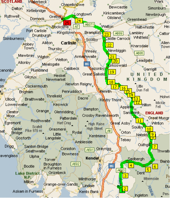
Today is the day. Today we reach a real milestone of our tour. We cross the border!
We are dropping the mileage a little today but will still cover a lot of ground. The route is fairly flat other than a gradient of approx 1100ft above sea level on the roads between Sedbergh and Kirkby Stephen. By now, this kind of hill should be no problem for us hill hardened riders!!
The day’s route follows the eastern leg of the Cumbrian Cycle way that traces the Eden Valley north-east between the Pennines and the Cumbrian mountains. We leave the refuge of Kirkby Lonsdale (1) and follow the River Lune through the villages of Casterton (2) and Middleton (3) before reaching the small market town of Sedbergh (4). From here a steep climb leads into the remote valley at Mallerstang and the source of the River Eden.
Again the river is followed north through a patchwork of grazing meadows that carpet the widening valley floor. The hills of the North Yorkshire Moors begin to retreat as the Lune merges into the estuary of the Solway Firth at the fortress town of Carlisle. We cross the River Rawthey at the far side of Sedbergh that commences the slow climb towards Garsdale (5), Garsdale Head (6) and Outhgill (7) before we pass through Nateby (8) and onto Kirkby Stephen (9).
The route now leaves the main road to cross the undulating hillocks that dominate the western fringe of the Pennines. We will pass through the village of Soulby (10), make a quick climb before a lovely descent into Great Ormside (11) and then pass through the beautiful village of Dufton (12). The cycleway continues through Knock (13), Millburn (14), Blencarn (15) and then onto Skirwith (16) and the town of Langwathby (17).
The road then joins another cycle track before we begin another steep descent to cross the Croglin Water and pass the villages of Salkeld Dykes (18), Kirkoswald (19) and Croglin (20). The road now gives way to a more pleasant section of easier ground which leads us through Newbiggin (21), Castle Carrock (22) and into Brampton (23).
The final 15 miles into Gretna are said to be relatively painless. The glacial ‘Kames’ that for form the hillocked landscape around Brampton is left behind as the route crosses the estuary of the Esk and the Eden. We follow the road which takes us through Longtown (24) on the River Esk. The road now continues easily across the border into Scotland to reach the town of Gretna (25) and a significant milestone on our journey!
Day 7 - Gretna to Kilmarnock - 92.6 Miles (Total 689.4 Miles) - HAPPY BIRTHDAY LAURA!
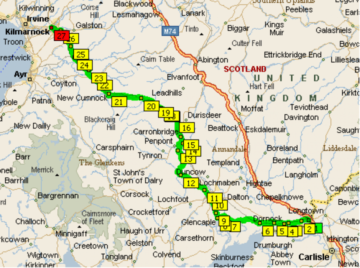
Today’s route crosses the border country of Dumfries and Gallowayin the Scottish Lowlands.
The Solway Firth cuts deep into the mainland giving rise to an intricate coastline that is perhaps some of the most beautiful in Britain. The route from Gretna follows the coast road along heather-covered hills fringed by sandy inlets with views south to the Cumbrian Mountains that are said to be particularly stunning in the early morning or at sunset.
The Nith Valley provides a setting for further northern progress and will compliment the route towards today’s destination. Today we will climb a few small hills. The largest ascents taking place on the roads between Sanquhar and Cumnock which top out at approx 550ft above sea level.
The day will begin in Gretna (1). We will leave the town crossing the River Annan and begin a slow short climb passing through Rigg (2), Eastriggs (3), Dornock (4) and Annan (5) before reaching Cummertrees (6). We will now continue more easily along this beautiful coastal section with the view across the Solway Firth to the Cumbrian Mountains. The road follows the course of the rail line to Dumfries.
We continue along the estuary bringing us to Bankend (7) which is nestled beneath the Bankend Hill. Passing through Glencaple (8) and Kelton (9) before starting another steady climb with views across the Mabie Forest to eventually arrive at the town of Dumfries (10). From Dumfries we pick up the local ‘KM cycle route’ and follow it passing Newbridge (11) and then onto Dunscore (12). We will now start the gentle descent into Keir Mill (13).
The terrain will now become suddenly more dramatic with the Kier Hills dominating the western horizon and the evergreen plantation of the Forest of Ae creeping onto the lower slopes of the Lowther Hills in the east. We pass through Thornhill (14), Carronbridge (15), Enterkinfoot (16) and then Mennock (17). The route now takes us through a impressive forest fringed lane that leads to the 17th centaury Drumlanrig Castle before passing through Drumlanrig Park on a high course above the Nith Valley on the west bank.
The road then descends to the west bank and follows the river past Eliock (18) and into Sanquhar (19). We continue along the Nith Valley with the Lowland Hills dominating the view all around. We pass through the town of Kirkconnel (20) before continuing to follow the course of the river onto New Cumnock (21) before leaving the sanctuary of the Nith Valley and a more undulating course is followed to Cumnock (22).
From Cumnock, the course takes us across the River Auchinleck before delivering us to a town by the same name (Auchinleck 23). The road is now pleasantly followed to the town of Mauchline (24) before passing through the suburbs of Kilmarnock which include the villages of Crosshands (25) and Hurlford (26). The final stop of the day is Kilmarnock (27) where we can set up camp and look forward to an evening spent under the stars, blowing out candles on a freshly baked cake courtesy of Jo and quaffing non-alcoholic champers.
Day 8 - Kilmarnock to Tyndrum - 90.2 Miles (Total 779.6 Miles)
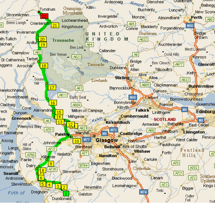
Today’s route is virtually all flat, until we reach the road between Ardlui and Tyndrum. Between these roads we will face a climb of approx 1100ft above sea level!
Today’s route endeavours to search out a course through the industrialised centres and suburbs clinging to the banks of the Clyde in the west and the Firth of Forth in the east. We start the day in Kilmarnock (1). Once we hit the road we will pass through the villages of Kilmaurs (2), Cunninghamhead (3), cross over the Annick Water to reach Montgreenan (4) and then onto Kilwinning (5).
We will now cross the River Garnock in Dalgarven (6) before passing by one of Scotlands oldest churches on a beautiful tree lined lane. Then through Dalry (7) and Highfield (8) before the road continues along the crest of a ridge above the Garnock Valley. On our way to the Erskine Bridge we will pass through Beith (9) before reaching Paisley (10) where the industrial skyline of Glasgow can be seen in the distance.
After crossing the River Clyde on the Erskine Bridge we will find ourselves in Old Kilpatrick (11) where we will now pick up the ‘Glasgow to Loch Lomond Cycle Route’ which runs parallel to the River Clyde utilising sections of disused railway lines before turning north along the towpath of the River Leven to follow the Leven Valley to Loch Lomond.
Whilst we are on the cycle route we will pass through (or near by to) Bowling (12), Dumbarton (13), Renton (14) and Alexandria (15) before reaching the start of Loch Lomond. We will then follow the western shore of Loch Lomond which takes us through Arden (16), Luss (17) and Tarbet (18) before delivering us safely at Ardlui (19) at the northern most tip of the Loch.
From Ardlui to today’s destination the route gets a little tougher with some large hill climbs. The route takes us through Inverarnan (20) and Crianlarich (21) before we finally reach Tyndrum. On the whole, probably better than camping next to the Loch as open water swimming is not something Stuart should be encouraged to do!
Day 9 - Tyndrum to Inverness - 114.9 Miles (Total 894.5 Miles)
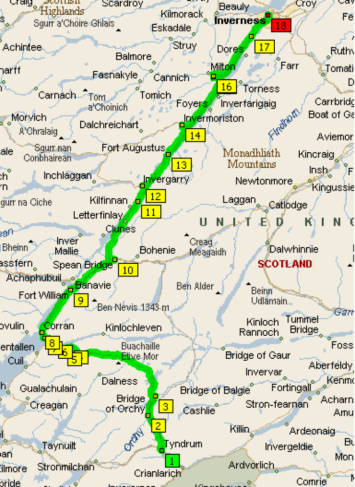
If the weather is favourable today promises to offer us some of the most memorable cycling one could hope for. The day will contain all the scenic diversity that typifies the west coast of Scotland.
The route begins in Tyndrum (1) with a steady hill climb (the highest we will face today peaking at approx 1000ft above sea level) along the narrow Glen Falloch and Strath Fillan, overhung with beech and crowded by the surrounding peaks. We will pass through Bridge of Orchy (2) and Achallader (3) before the inhospitable wilderness of Rannoch Moor will leave us riders seeking the security of Glen Coe (4) with mountain scenery as dramatic as anywhere in Scotland.
After a wee climb we will make a final welcome descent off the moor and enter Glen Coe. The entrance of Glen Coe is guarded by the peaks of Beinn, providing us riders with an uncomfortable but beautiful welcome. We now continue on our route passing Ballachulish (5),North Ballachulish (6) and Onich (7) on the way. The scenery will now suddenly change from classic Upland Mountain into a rugged, coastal setting.
The road follows the headland and passes through Corran (8) before following the shore line of Loch Linnhe and going around the base of the peaks of Beinn an Mhoir and Beinn na Cucaid to the town of Fort William (9). As we leave the town of Fort William behind us, we will be able to see the whale-backed peak of Ben Nevis with the Allt a Mhuilinn leading up into the dark recesses of the north face cliffs. The road continues easily through the Leanachan Forest to reach Spean Bridge (10).
The road now leads us out of Spean Bridge, over a wooded hummock followed by a soft descent down the hillside of Coire Ceirsle before joining the River Gloy on its route to the banks of Loch Lochy. Peaks rise steeply all around the depths of the mirrored loch water, creating a truly memorable scene. Have your cameras ready!
The road undulates easily beneath a canopy of greenery as we pass through Laggan (11). At the head of the loch a final descent leaves the Laggan Forest and crosses the Caledonian Canal. The next town we pass through is Invergarry (12) which will act as a place for a quick pit stop at the head of Loch Oich.
We shall now continue along the west bank of Loch Oich before crossing the Caledonian Canal once more. The route to Fort Augustis (13) picks a course through the glacial hillocks deposited at the head of the most famous of all Scottish lochs, Loch Ness. No Stuart, stay away from the water!!!
The road now continues along the shore of Loch Ness below the Port Clair Forest before making a short detour to cross the River Moriston at Invermoriston (14). Creagnaneun Forest now hugs the steep slopes above Loch Ness before delivering us to Drumnadrochit (15) half way up the Loch. Finally we pass through Lewiston (16) and Lochend (17) located at the northern-most point of Loch Ness before continuing onto today’s destination, Inverness (18).
Day 10 - Inverness to John O'Groats - 123.3 Miles (Total 1017.8 Miles)
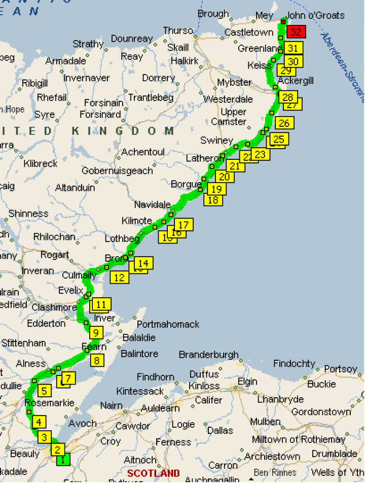
So, today is the day we make the home run and the big push towards our final destination.
The concluding leg of our journey follows the north-east coast road out of the Highlands into the open moor lands characteristic of the Scottish north coast.
The route is as flat as any we have so far encountered; therefore, covering a high number of miles will be no problem today. The route follows a lonely course and taken in isolation the day would not be considered the most memorable of cycle tours but as a climax to our tour that has spanned the countryside of Great Britain it is a fitting finale and something we should all enjoy.
The stretch of coastal road spanning from the outskirts of Inverness to the north-eastern tip and John O’Groats is as isolated as expected and lives up to all preconceptions that one may associate with this part of the journey.
The day begins in Inverness (1) before crossing the Beauly Firth into North kessock (2) where we pick up the coastal road which will lead us all the way to the finish line. We will pass through the towns of Tore (3) and Duncanston (4) before crossing the Moray Firth and reaching Evanton (5).
We will then begin to follow the course north passing through Dalmore (6), Rosskeen (7), Kildary (8) and Morangie (9) before crossing the Dornoch Firth and reaching Evelix (10). Cycling through Proncy (11) the road takes us right onto the coast of the North Sea for the rest of our journey. Now it is just a question of staying focused and covering the ground required to reach our target.
We will pass through Golspie (12), Doll (13), Brora (14), Kilmote (15) and Portgower (16) before finally reaching Helmsdale (17). From here stunning views across the rugged coastline of the North Sea is a (small) reward for our efforts as the road begins to lead us down a series of steep descents taking us through the villages of Berriedale (18), Borgue (19) and Dunbeath (20) which all offer welcome sanctuary to us weary riders.
As the route continues it will be noticeable that the ridges and peaks of the Highlands have receded onto the western horizon and been replaced by more open grass land combed by the relentless winds that sweep this north-eastern headland. The road winds northwards passing through Latheronwheel (21), Swiney (22), Occumster (23) before continuing through Bruan (24), Ulbster (25) and by the time the village of Thrumster (26) is reached the cycling has become very straight forward. A little further on from Thrumster we reach Wick (27).
As we leave Wick we will pass the twin ruins of Sinclair and Girnigoe Castles clinging precariously to the cliff tops. We will now pass through the villages of Ackergill (28), Keiss (29), Auckengill (30) and Freswick (31) before we follow the last bit of coastal road across a harsh landscape of Tussock grassland. A short climb (our very last of the trip!) over the Warth Hill leads to the final descent to the coast and the small village of John O’Groats.
We have made it. What has all the fuss been about?!
After a quick photo op at the famous John O'Groats white sign posts (completing the set) we can head for camp.
I wonder how many of us will be awake for the two day car ride home...
